High winds force outages: Hundreds lose power in storm
Published 9:55 am Tuesday, March 28, 2017

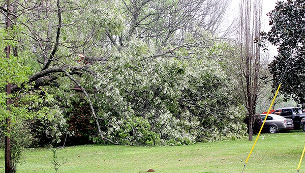
- A home on Jeff Davis Rd is engulfed by a downed tree following storms on Monday night and Tuesday morning. Residents experienced outages for upwards of 10 hours. (Courtland Wells/Vicksburg Post)
A severe thunderstorm rolled into the southern part of Warren County Monday evening, causing extensive damage.
The storm originated in Louisiana around Tensas County and produced large hail and damaging winds. Daniel Lamb, a forecaster with the National Weather Service in Jackson, said that the damage in Warren County is evidence of wind gusts in excess of 60 mph, but that they don’t have an exact measurement from the areas that were the most affected.
Entergy’s Shelia McKinnis confirmed that at the peak of the storm, 1,102 people in Warren County were without power, mostly due to trees falling on power lines.
As of 8 a.m. Tuesday, 326 customers were still without power, but McKinnis said the expectation is that all customers should have power restored by 2 p.m.
The storm also damaged approximately five houses and caused multiple temporary road closures, that were cleared by Tuesday morning according to John Elfer, the director of Warren County Emergency Management.
As of 8 a.m., portions of Campbell Swamp Road were still closed.
Warren County Sheriff Martin Pace said trees were toppled, and in some cases power lines were down and poles snapped, on Wright Road, Jeff Davis Road, Gullet Road, Dogwood Road, Hankinson Road, Campbell Swamp Road and others areas in southern Warren County.
“We had extra deputies out during the storm, and by morning road crews had cleared all of the downed trees, other than those that were entangled with power lines,” he said. Road crews can’t remove those trees until Entergy personnel handle the issue with the downed power lines.
The department also worked with the Vicksburg Warren School District to re-route buses as needed.
Monday’s storms were the first in a series of severe weather systems that are expected to affect Vicksburg and Warren County this week.
“We will have another more potent system coming through a little bit later on this week from late Wednesday night into the day Thursday,” Lamb said. “There is still a little bit of uncertainty as to how that storm is going to play out, but there is the potential for a couple of rounds of storms.”
Lamb said the first round is expected to roll in late Wednesday night and there is the potential for a second round to redevelop Thursday afternoon.
The storm has the potential to include large hail, damaging winds and tornadoes.
“We certainly urge people to keep checking for the latest forecast as that system approaches because there is the potential that some of those storms could be quite potent,” Lamb said.


