Not over yet: Snow falls as county braces for another round of winter weather
Published 9:38 am Tuesday, February 16, 2021
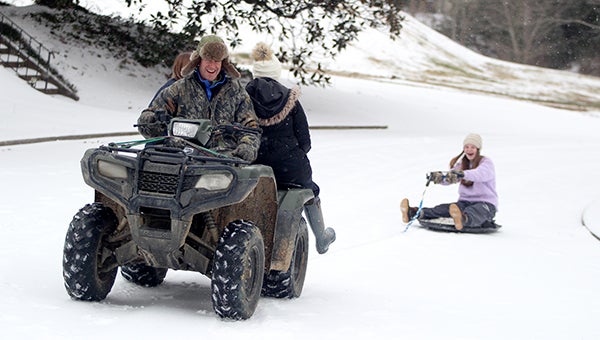
- Phillip Doiron uses a four-wheeler to pull children on a sled over frozen streets Monday in the Glenwood Circle neighborhood. (Tim Reeves/The Vicksburg Post)
After experiencing a winter storm that dumped up to 4 inches of a wintry mix on Warren County, residents in some areas of the county woke up Tuesday to see snow falling in their yards.
“What we have is some low shallow moisture still in the area,” said National Weather Service meteorologist Logan Poole. “We can expect about a quarter- to a half-inch.”
The snow is the last remnant of Monday’s winter storm that forced most county residents indoors. Temperatures Monday night stayed in the upper teens and did not get below 10 degrees as predicted.
And as people recover from Monday’s event, officials are getting ready for the next storm system forecast to hit the area Wednesday and Thursday.
But whether the area is hit by a rain event or freezing rain will all depend on the temperature.
“If the temperature is above freezing, we can expect rain, if it’s below freezing we’ll have ice. It’s going to be close,” Poole said. Presently, he said, the Upper Delta is most at risk for freezing rain, “But that could move south.”
“This could be an ice event,” Warren County Emergency Management Director John Elfer said. “A decision will be made shortly whether to close the courthouse. Interstate 20 is still dangerous and still closed between Mile Markers 5 and 9. This is going to be bad.”
The forecast for Tuesday shows highs in the upper 20s with lows back into the teens. Highs Wednesday are expected to be in the mid-30s with lows in the low 30s.
Wednesday’s forecast calls for a chance of light freezing rain, showers and a slight chance of snow showers and light sleet in the morning followed by showers, freezing rain and light sleet in the afternoon.
Thursday’s forecast calls for showers, light freezing rain and snow showers with a slight chance of snow showers, showers and light freezing rain in the afternoon.
Highs will be in the mid-30s with lows up to 20 degrees.
About John Surratt
John Surratt is a graduate of Louisiana State University with a degree in general studies. He has worked as an editor, reporter and photographer for newspapers in Louisiana, Mississippi and Alabama. He has been a member of The Vicksburg Post staff since 2011 and covers city government. He and his wife attend St. Paul Catholic Church and he is a member of the Port City Kiwanis Club.
 More by John
More News


SportsPlus
NFL Week 8 Picks Against the Spread, Tips and Predictions
Looking for the best against-the-spread bet among all 16 NFL games in Week 8? Our choice, in terms…
NFL Week 8 Computer Predictions, Best Bets, Over/Under Picks
According to our projections, the best bet versus the spread in the NFL among Week 8’s 16 games…
How to Watch the NBA Today, October 23
The Indiana Pacers versus the Detroit Pistons is one game in particular to catch on a Wednesday NBA…
Foster Moreau Fantasy Projections: Week 8 vs. the Chargers
In Week 8 (Sunday at 4:05 PM ET), tight end Foster Moreau and the New Orleans Saints will…
Derek Carr Fantasy Projections: Week 8 vs. the Chargers
Derek Carr and the New Orleans Saints will play the Los Angeles Chargers and their ninth-ranked passing defense…
-
Polls
 Loading ...
-
-